Wokingham District Veteran Tree Association

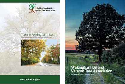
This report is a summary of the 2006 to 2024 veteran tree survey by Wokingham District Veteran Tree Association (WDVTA).
It is intended to be an addendum to the 10th Anniversary report published in 2017.
This online report is an extended version of a printable edition (PDF).
In 2005 the sound of a chainsaw and the felling of a fine mature English oak marked the loss of yet another well-loved veteran tree in Wokingham Town. It was the impetus for founding of WDVTA in 2006/7 as a response to a period of increasing threats to old trees in Wokingham.
In 2006 a generous grant from the Wokingham Society allowed the initial organisation of a survey of veteran trees in Wokingham Town. In 2007 this was expanded to a District / Borough-wide survey funded by a National Lottery grant of £10,000 with contributions and support from Wokingham Borough Council and Town and Parish Councils across the borough.
Following the publication of a report in 2012 on the veteran Trees in Wokingham Town, WDVTA published a further 10th Anniversary Report in 2017 charting the progress of veteran tree surveying by volunteers from across the whole of Wokingham Borough. All 17 towns and parishes in the borough were described individually.
The report highlighted the establishment of a borough-wide database and website, the production of a quarterly e-newsletter Tree Watch, membership of The Tree Council tree warden scheme, and a variety of other activities such as talks, training, walks and visits.
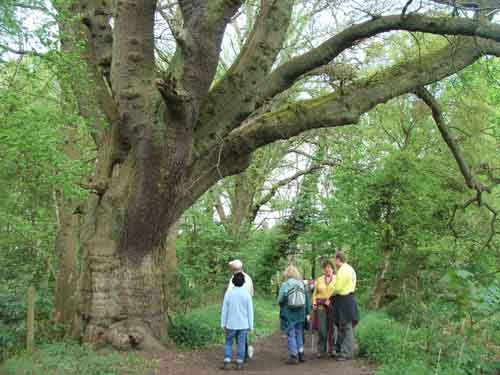
Veteran trees have reached full maturity and show signs of ageing such as cavities and bark loss, all good habitats for wildlife. The age at which this occurs varies with species – an oak will take far more years than a silver birch.
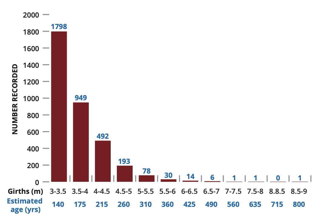
A tree’s status is indicated by its girth: an oak with a girth of 4 metres could be over 200 years old. Our recorded trees are classified by the Ancient Tree Inventory as notable, veteran or ancient.
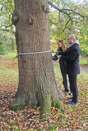
For most tree species (e.g. oak, ash) we only recorded trees with a girth greater than 3m, measured at 1.5m above ground level.
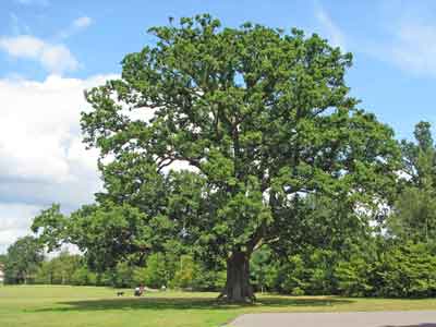
By 2025 more than 140 volunteers had surveyed, recorded and photographed over 8,500 notable, veteran and ancient trees. These are mapped and detailed on the map page.
Every recorded tree in all the borough’s 17 towns and parishes appear on this map and further details about each tree can be accessed by clicking the relevant icon. The information includes when the tree was recorded, its grid reference, girth and condition when recorded as well as photographs and any subsequent updates.
The data has been sent to Wokingham Borough Council, the Ancient Tree Inventory via the Woodland Trust, the Thames Valley Environmental Records Centre and the National Biodiversity Network.
The WDVTA committee was determined that the survey should be carried out to the highest possible standards to ensure the usefulness and credibility of the results. To this end a Surveyors Handbook was created to define the methodology to be used by surveyors so that the results should be as accurate and consistent as possible given the skills, tools and technologies available to the volunteers.

Volunteers were encouraged to work in pairs. The basic equipment comprised an OS map, a camera, a tape for measuring tree girth and a means to record tree location. The Association purchased a number of GPS devices (this was before the advent of phones with GPS features) which were loaned to participating surveyors. Standardised recording sheets were drawn up to ensure all relevant information about each tree was captured.
A web-based map tool was commissioned which enabled surveyors to locate a tree's position on an online OS Map and read off the OS grid reference. This tool greatly improved the accuracy of the readings captured by the GPS devices.
Surveyors would then submit their recordings to an area coordinator for checking. The coordinator in turn sent the results to the database coordinator who assembled the information into the WDVTA veteran tree database.
In 2010 WDVTA recognised that data had been collected over a period of time during which the tools, training and techniques had greatly improved through experience and feedback from members. The completeness of the information was variable - some early records had no photographs and other information that is now considered essential could be missing. A database verification process was initiated and systematic checks were carried out on a sample of records where information seemed incomplete or ambiguous or where the tree in question was particularly significant. Where appropriate, records were updated and the verification results were published.
A summary review recommended changes to improve the quality of future measurements.
Full details of the survey processes and methodologies can be found here.
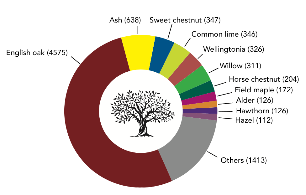
English oaks are by far the most common species of veteran tree found across the borough. They account for over half the trees in the database and reflect the history of Wokingham as part of the Royal Forest and its industry, providing a source of wood for building and oak bark for tanning.
For most tree species (e.g. oak, ash) we only recorded trees with a girth greater than 3m, measured at 1.5m above ground level.
The chart shows there is a sharp decline in the numbers of maiden English oaks from nearly 1,800 with girths between 3.0 and 3.5 metres to just 3 oaks which are over 7 metres. Further analysis is needed to suggest reasons for this decline.
Other species recorded include natives (such as ash, field maple and hawthorn), trees used for agricultural and industrial purposes (such as sweet chestnut and crack willow), and decorative and exotic species (such as common limes and Wellingtonias) planted in parklands and gardens.
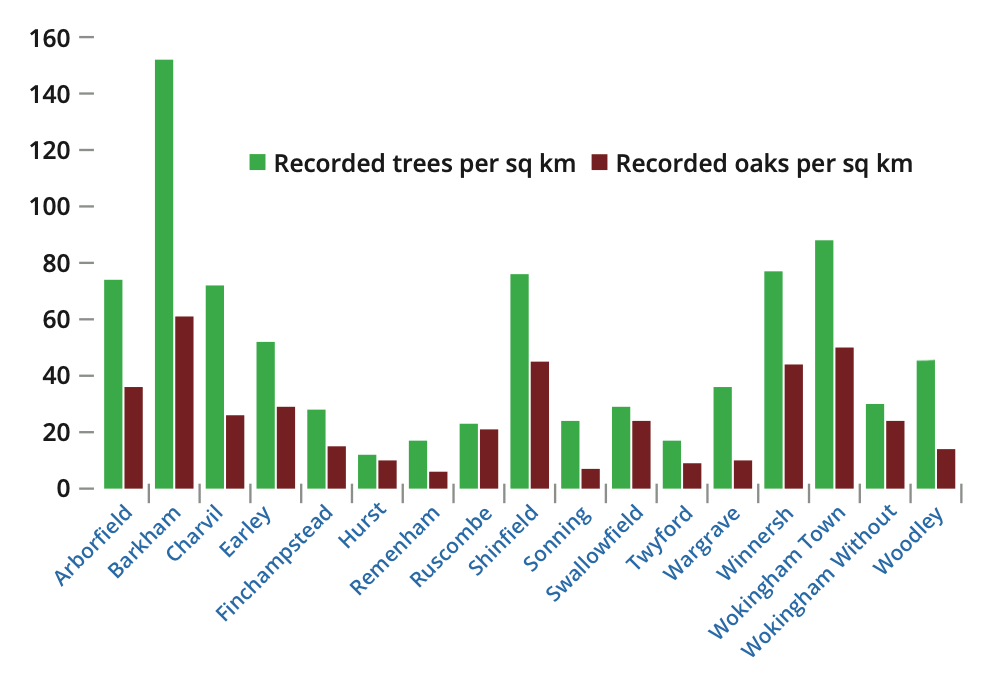
With the completion of the survey we were able to calculate the density of all recorded trees and all recorded oaks for each parish and town. The variation across the seventeen parishes and towns is significant and further analysis would be useful to identify the reasons for the marked differences.
Charts in the above sections were designed by NP Design & Print, Wallingford
In 2019 WDVTA members carried out a project measuring tree canopy cover in the borough of Wokingham using an application called i‑Tree Canopy developed by the US Forestry Service and introduced to the UK by Forest Research.
i‑Tree uses in-built data analysis based on randomised samples of Google satellite images within a defined area. At each sampled point the i‑Tree operator decides whether or not the point is on a tree canopy and by aggregating the results the extent of tree cover over the area can be estimated.
The areas we chose were the 17 parishes and towns comprising Wokingham Borough. The figures generated by the application provided an estimate of the percentage of tree cover for each parish and the results are shown in the chart below. Finchampstead had a significantly higher than average proportion of tree cover whilst Shinfield had much less. The canopy cover for the whole borough was about 26%.
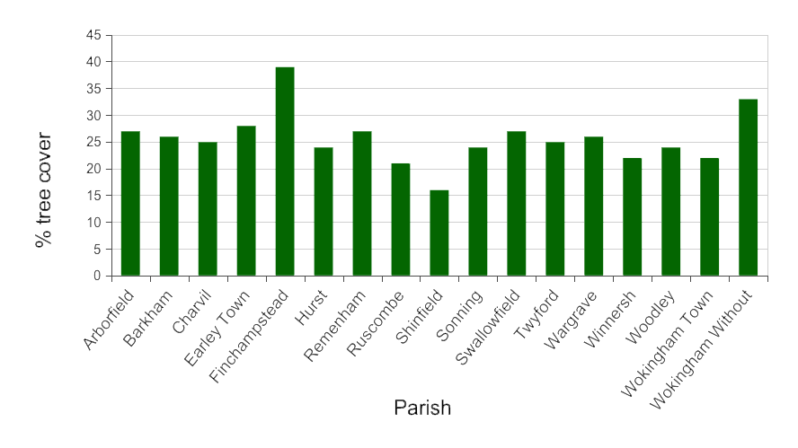
The i‑Tree project was separate from the survey described in the main body of this report but the analysis gives an alternative view of Wokingham's trees based on satellite data compared with the on-the-ground methodology of the veteran tree survey.
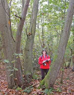
In responses to a questionnaire in 2025 on their tree surveying experiences, many volunteers reported great pleasure in having spent time in the countryside in the company of like-minded people. They enjoyed learning more about old trees and how to identify and record them using modern technology. Many were fascinated to discover the connections between veteran trees and local history.
Surveyors reported that their experiences significantly increased their awareness of the aesthetic, cultural and environmental importance of veteran trees in local communities.
In spite of obstacles such as scrambling through brambles, nettles and ditches and the occasional refusal of access, they found most local people were interested in, and supportive of, what they were doing.
Here is the full report (PDF) on the surveyors' responses to the questionnaire.
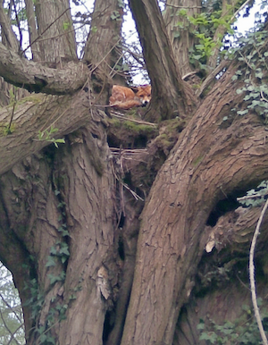
With the completion of the Veteran Tree Survey it is useful to look back at the entire project, its methodologies, the tools used and the project management so that lessons can be learned for any similar projects that we, or indeed any other voluntary organisation, might choose to embark on in the future.
For this review we are taking three perspectives:
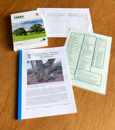
There is no doubt that the creation of a Surveyor's Handbook was a major contributor to the success of the project. This comprehensive manual set out in detail how surveyors should carry out their tasks to ensure as much accuracy and consistency as possible. Best practice techniques from organisations such as The Tree Council and Woodland Trust formed the basis of the documented guidance. The Handbook also carried associated information such as the relationship of tree girths to age. Its contents were kept under continual review to ensure readers had access to the best advice and guidance available.
Rather than asking individuals to provide their own tools for recording tree information, WDVTA purchased measuring tapes, GPS devices and USB drives to help surveyors record the information to the highest standards possible.
Proforma recording sheets were provided so that information could be recorded consistently and as concisely as possible.
When the survey started in 2007 domestic GPS location technology was in its infancy. GPS devices were expensive with location measurements accurate to no more than 8 Ordnance Survey (OS) digits. Although WDVTA bought some devices for loan to surveyors, some users relied solely on an OS map to determine their location. Early results therefore were often inaccurate. With the advent of more accurate GPS devices and GPS-enabled phones the accuracy of later results was greatly improved.
Species identification benefited from the advent of phone apps which were beginning to replace traditional tree identification guides.
Apps now available for measuring distances and sizes of objects would have helped in measuring tree girths when the terrain made it difficult for surveyors to get close enough to measure with a tape.
Feedback from surveyors enabled the Surveyors' Handbook to be regularly improved.
Most surveyors gained proficiency in carrying out the activities and results obtained in later years were undeniably more accurate than their early efforts.
It was assumed that surveyors would correctly identify tree species. Some trees however were logged by two different names such as 'oak' and 'English oak' or 'lime' and 'common lime' apparently giving rise to different identities in the database.
We could have avoided this in two ways:
The minimum girth to qualify as a veteran tree was set at 3 metres, regardless of species. This is appropriate for an oak but not satisfactory for trees with a faster growth rate such as Wellingtonias. This detail should have been given greater emphasis in the guidance given to surveyors.
Some surveyors tended to record trees that did not meet the minimum girth criterion. This resulted in an over-recording of maidens as well as inclusion of multi-stem trees whose age may not have justified inclusion.
During the lifetime of the survey a feature, Grid Reference Controls, was added which enabled a user to read off an OS grid reference by positioning a cursor on the Google tree map. This, together with the GPS reading taken in the field when entering the tree position, enabled a more accurate location to be recorded.
Surveyors would occasionally record a tree as being by the side of a road without making it clear which side they were referring to. Given that GPS readings could be subject to uncertainty of 10 metres or more this could create ambiguity. In these environments surveyors should have been encouraged to spend more time on completing the textual description of the location.
Access to large areas of the Borough was limited owing to the spaces being in private ownership. In some cases, surveyors were able to negotiate access with the landowner but this was not always possible. Occasionally, permission was refused because owners were under the mistaken impression that WDVTA would be filing Tree Preservation Order (TPO) requests with the Council. This reluctance could sometimes be overcome by careful and respectful explanation of the surveyor's role but an outright refusal to cooperate was an insurmountable barrier.
Despite the wealth of helpful and concise information in the Surveyor's Handbook it is likely that surveyors had not read or completely absorbed the relevant contents, or failed to familiarise themselves with updates. More emphasis should have been placed on the importance of taking note of the guidance in the Handbook but coordinators may well have felt disinclined to point out the importance of reading the material or to feed back to surveyors what they felt might have been viewed as criticism.
Greater emphasis on adhering to Handbook guidance would have helped to offset this difficulty. Parish coordinators would have played a significant part in maintaining these standards.
In 2010/2011 it was decided to conduct a verification exercise to assess the reliability of data collected. To this end an independent check was made on a sample of trees in the database with the aim of checking the accuracy of the entries and, if necessary, updating the entry where there were found to be inaccuracies or errors. These inaccuracies might arise through incorrect identification of species or inaccurate recording of location (for example when a more accurate GPS reading could be taken with newer equipment). This exercise was also useful in taking photographs where previously absent.
The results were encouraging, showing that very few trees had been incorrectly identified. More accurate location data was obtained for about half of the trees sampled. It was found however that it could be difficult to locate an individual tree from the database in woodland areas owing to the number of trees present and the inaccuracy of GPS positioning under extended tree canopy.
The veteran tree survey has undoubtedly been a great success in cataloguing over 8000 trees - a significant proportion of the notable trees in the borough of Wokingham. The project has raised the profile of WDVTA and its achievements have been recognised by councillors, council officers, national tree organisations, members of the public and, not least, by WDVTA members themselves. The success has been powered by the enthusiasm of the members and by the strength of the processes and methodologies underlying the whole activity from its inception to completion.
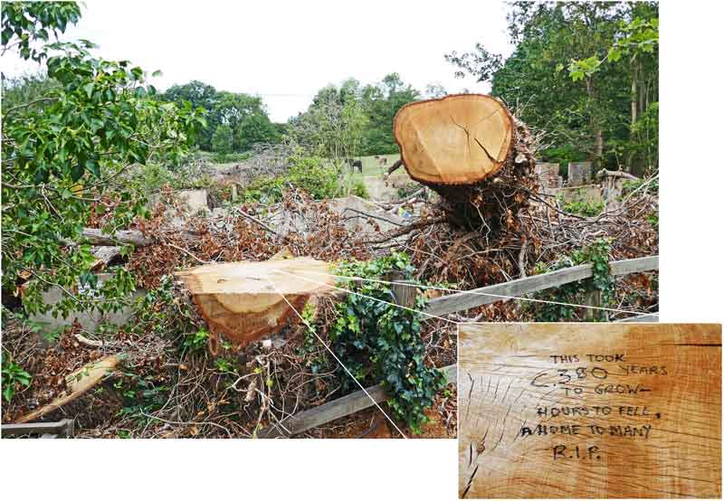
We noticed the continual loss of veteran trees throughout the 20 years of the survey. Of the 8,696 trees recorded, 273 were dead when surveyed. Most of these were stumps but 13 were initially recorded as dead and standing, with 2 dead and fallen.
A further 258 trees, living when recorded, have been lost since the survey began in 2006. Reasons include natural decline, storm damage, disease, safety concerns and development, both legal and illegal.
These lost trees are just those we have been informed about. Sadly, there will be others lost across the borough that we don’t know about because we have not systematically checked all recorded trees.
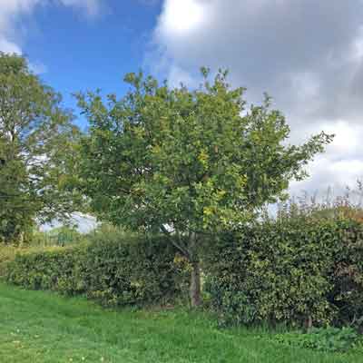
The loss of so many old trees over the last 20 years from Wokingham Borough is a warning that future generations will not be able to enjoy all of the many health and environmental benefits which such trees bring - unless action is taken urgently. It will take at least 150 years for any newly planted trees to reach veteran status, but there are trees growing today which could become veterans in a much shorter time if they were identified and protected.
Volunteers saw many of these younger notable trees across the borough in hedges, woodlands and parks, but they did not record them as their girth was less than 3 metres. A project to nurture these trees to become the veterans of the future would bring many benefits to the borough.
In the last 50 years many hedges as well as trees within hedges have been lost. The Tree Council encourages us to advocate for the planting of new trees in hedges as well as cultivating potential trees in existing hedges.
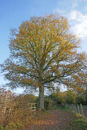
Whilst the Veteran Tree survey was closed in 2024, the information will continue to be accessible on this website via the map page and the database page. The data can be used to support the protection of old trees and inform planning decisions. It also provides information for environmental research in the area.
WDVTA is now linked with The Tree Council's tree warden scheme and voluntary tree-related activities will continue. The WDVTA quarterly newsletter Tree Watch is sent to all members and all issues are available.
New members are welcome and can join WDVTA here.